


MapTiler Mobile
Beschreibung von MapTiler Mobile
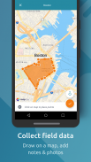
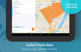
See your GPS position on your own maps. Draw points, polygons and lines on the maps. Collect field data and notes related to a location, attach a photo and fill custom properties.
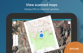
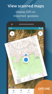
Display offline maps generated with MapTiler (https://www.maptiler.com).
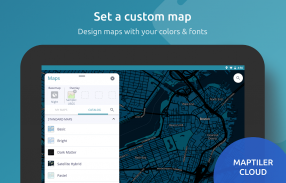
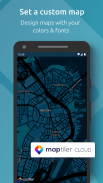
Choose from various basemaps like street and satellite. Preview on a mobile device the map you previously designed with own colors and fonts in MapTiler Cloud.
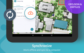
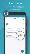
The app supports GeoJSON and MBTiles formats and data synchronization between multiple devices and desktop computer using cloud. I it easy to share the data with other people and collaborate! Perfect for mobile data collection for GIS and surveys.
Import scanned hiking maps, PDF maps, drone aerial imagery, nautical charts for sailing and navigation with a boat or a yacht, fishing maps, aeronautical charts for flight planning by pilots, parcels and city plans and other opendata from local government. OpenStreetMap vector maps are powered by OpenMapTiles project (the successor of OSM2VectorTiles). Maps can come from existing tile servers with OGC WMTS, TileJSON or XYZ tiles from.
Supported geodata formats by MapTiler: GeoTIFF, TIFF, JPEG, ECW, SID / MrSID, NOAA KAP / BSB, DEM, OziExplorer OZI OZF2 & OZFX3, WebP, JP2, JPEG2000, GeoJP2, Erdas, Grass, Safe, Sentinel2, SRTM, NASA imagery, USGS map sheets, exports from ESRI ArcGIS, ArcSDE, etc.
The GeoJSON can be converted from / to: ESRI ShapeFile (SHP), DXF, DWG, GPX, CSV and KML.
Sehen Sie Ihre GPS-Position auf Ihren eigenen Karten. Zeichnen Sie Punkte, Polygone und Linien auf den Karten. Sammeln Sie Felddaten und Notizen zu einem Standort, hängen Sie ein Foto an und füllen Sie benutzerdefinierte Eigenschaften aus.
Zeigen Sie Offline-Karten an, die mit MapTiler (https://www.maptiler.com) erstellt wurden.
Wählen Sie aus verschiedenen Grundkarten wie Straße und Satellit. Zeigen Sie auf einem Mobilgerät eine Vorschau der zuvor in MapTiler Cloud mit eigenen Farben und Schriftarten erstellten Karte an.
Die App unterstützt die Formate GeoJSON und MBTiles sowie die Datensynchronisierung zwischen mehreren Geräten und Desktop-Computern mithilfe der Cloud. Ich habe es einfach, die Daten mit anderen Menschen zu teilen und zusammenzuarbeiten! Perfekt für die mobile Datenerfassung für GIS und Umfragen.
Importieren Sie gescannte Wanderkarten, PDF-Karten, Luftbilder von Drohnen, Seekarten zum Segeln und Navigieren mit einem Boot oder einer Yacht, Angelkarten, Luftbildkarten für die Flugplanung von Piloten, Parzellen und Stadtplänen sowie andere Opendaten der örtlichen Behörden. OpenStreetMap-Vektorkarten werden vom OpenMapTiles-Projekt (dem Nachfolger von OSM2VectorTiles) unterstützt. Karten können von vorhandenen Kachelservern mit OGC WMTS-, TileJSON- oder XYZ-Kacheln stammen.
Von MapTiler unterstützte Geodatenformate: GeoTIFF, TIFF, JPEG, ECW, SID / MrSID, NOAA KAP / BSB, DEM, OziExplorer OZI OZF2 und OZFX3, WebP, JP2, JPEG2000, GeoJP2, Erdas, Grass, Safe, Sentinel2, SRTM, NASA Bilder, USGS-Kartenblätter, Exporte aus ESRI ArcGIS, ArcSDE usw.
Der GeoJSON kann konvertiert werden von / nach: ESRI ShapeFile (SHP), DXF, DWG, GPX, CSV und KML.
MapTiler Mobile – Version 2.0.1
(12-03-2020)MapTiler Mobile – APK Informationen
APK Version: 2.0.1Paket: com.maptiler.geoeditorNeueste Version von MapTiler Mobile
Weitere Versionen


 4.34
4.34


Apps in derselben Kategorie


Das könnte dir auch gefallen...


